Wednesday, May 31, 2023

St George

Our route when leaving Fredonia was on SR 389, and then transition to UT SR59

Arizona State Route 389, also known as SR 389, is a state highway in far northern Arizona serving the Arizona Strip. SR 389 stretches from the Utah border at Colorado City, southeast to Pipe Spring National Monument, and ends at U.S. Route 89A in Fredonia; it is the only major east–west route between these two towns, and also serves to connect Fredonia with points farther west such as St. George, Utah.

History - SR 389
SR 389 was established in 1959 along its current route.

Utah State Route 59 is a state highway in the U.S. state of Utah. The highway connects Hurricane to the twin cities of Hildale and Colorado City, Arizona. The highway connects to US-89A through Arizona State Route 389.

History Utah State Route 59
The road from SR-15 (now SR-9 and SR-17) at La Verkin Junction south to Hurricane was added to the state highway system in 1912, and in 1914 it was extended southeast via Big Plain Junction to Arizona.[4][5] In the 1920s, the entire route was numbered State Route 16.[6] A connection from SR-15 (now SR-9) in Rockville south to SR-16 at Big Plain Junction became a state highway in 1925.[7] In 1927, SR-16 was moved to the Rockville-Arizona route, and the roadway between La Verkin and Big Plain Junctions became part of the new SR-17, which also went southwest from Hurricane to SR-1 (US-91, now I-15).[8] The Hurricane-Big Plain Junction branch was split from SR-17 in 1931, becoming a new State Route 59.[9] The entirety of SR-16 was deleted in 1935, permanently removing the Rockville-Big Plain Junction road from the state highway system;[10] the highway beyond Big Plain Junction to Arizona was also removed, but was re-added in 1941 as part of SR-59, forming the present extent of that route.[11] SR-59 was almost completed relocated in 1962, including a new crossing of the state line; it had ended at the west end of Uzona Avenue, which extends west along the border from Colorado City/Hildale, but now crosses within the city limits.[5] The connecting State Route 389 in Arizona was not added to that state's state highway system until 1959.[12]


Here is the one main thing to KNOW - there is little to NO cell phone service along this Highway. 


Anyway, we left around 8:40, Susan was driving with Dakota and Tilly providing the needed navigation. 

No didn't say that Driving was easy


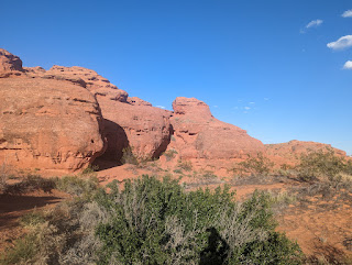
It's always good when things comes together or better yet no issue. The into Utah was smooth and quite, very little traffic that time of the morning. The entrance into Utah was smooth and I had time for 1 photo:


Our arrival was around 1, MDST at the Elk's Lodge in St. George. Setup was easy and quick. Cost is $25 per night with Electric. Water and Dump site is available. 

DaGirls Rv

The temps are expected to be in the High 80's. 


Jeff notice the Golf Course

Our afternoon, took us into old town - to see some of the LDS history, however most of the building were closed. We also went to Pioneer park which was close by, and took a small hike around.


DaGirls Rv AKA Gus
Susan, Tilly, Dakota and me


Tuesday, May 30, 2023

Day 2

 Wait Day 2? what do you mean. This is the 3rd day since leaving. Yes 3rd day since leaving but only the 2nd day of traveling. But, let me catch you up on where we have been.

As I explain we landed at the Kaibab Paiute Rv CG just west of Fredonia.  

To read all the reviews along with mind - Press Here 

Wonderful place to stay as it is a Dark Sky area. The cost using Passport America was $12.50 / night.


A small walking trail is nearby, allowing about a 3/4 mile walk one way. The back. There is a National Monument within 1/2 mile. The National Government and the Paiute Nation have a working agreement. 


Learn all about the spring water that was the life blood to the Paiute. But the LDS built a fort on top of the spring. 


Pipe Spring was named by the 1858 Latter-day Saint missionary expedition to the Hopi mesas led by Jacob Hamblin. In the 1860s Mormon pioneers from St. George, Utah, led by James M. Whitmore brought cattle to the area, and a large cattle ranching operation was established. In 1866 the Apache, Navajo and Paiute tribes of the region joined the Utes for the Black Hawk War, and, after they raided Pipe Spring, a protective fort was constructed by 1872 over the main spring. The following year the fort and ranch was purchased by Brigham Young for the Church of Jesus Christ of Latter-day Saints (LDS Church). The LDS Bishop of nearby Grafton, Utah, Anson Perry Winsor, was hired to operate the ranch and maintain the fort, soon called Winsor Castle. This isolated outpost served as a way station for people traveling across the Arizona Strip, that part of Arizona separated from the rest of the state by the Grand Canyon. It also served as a refuge for polygamist wives during the 1880s and 1890s. The LDS Church lost ownership of the property through penalties involved in the federal Edmunds-Tucker Act of 1887.

Although their way of life was greatly impacted by Mormon settlement, the Paiute Indians continued to live in the area and by 1907 the Kaibab Paiute Indian Reservation was established, surrounding the privately owned Pipe Spring ranch. In 1923, the Pipe Spring ranch was purchased and set aside as a national monument to be a memorial to western pioneer life.

Thanks to Wikipedia 


No one knows what the "P" stands for


There is also a ridge which you can hike up to. Well that seem to good to pass up. 


I know, I know. 


Finally, to start the day we arrived in time for Raising of the Flag:


Tribal Leader who served, led the Raising


DaGirls Rv AKA Gus 
Susan, Tilly, Dakota and me


Monday, May 29, 2023

And Now for the Rest of the Story

 Apache Death Cave - Question was it true.

Further investigation - I was amaze how much information on this subject is on the web. The first search that came up was about what happen.


Was it Real  - Or not real, yes you read this correctly, further investigation into what really happen is totally amazing. All because of 1 man.  The Question is are you person enough to read the whole article? 

Well are You ? Only way to know Fact from Fiction is to read the article.

If you can, then here is the Rest of the Story 


The Rest of the Story  


DaGirls Rv

Susan, Tilly, Dakota and me


Sunday, May 28, 2023

Today is the Day

Ok, day 1, Mike and Lorraine left, we did all the rv stuff, moved vehicles around, connected the truck, checking lights and watching the wheels roll. Huh what was that sound? Truck still in gear? No, in neutral, then what was it? Looked and checked, everything seems good. Susan started driving on 260 and Thump, Thump, Thump, what is that sound? It’s in the pattern of tire rotation. Next thing Clunk, and all is good. So, here we are on 260, not even a mile from the cabin, pulled to the right lane (no shoulder), emergency lights on. After careful inspection of all tires, looking underneath, we take off driving, good no sound. Now what? Well, we decided to pull into a lot so I could get a closer inspection of the tires. Even though we have a tire monitor, a good hammer, touching and watching the tire roll is still the best inspection method, they have developed.

Sorry no Photo, but I notice a big rub spot on the passenger inside dully. Best guess, is I picked up a good size rock driving out of the driveway.

Finally, by 8:49 we were on DaRoad and traveling. Need I say, this pass week the weather has been wonderful, 40’s – low 50’s at night and 70’s during the day. We are currently traveling up to Holbrook, with a stop at T/A to top off the tank, this will be the last place for the TSD card. The next fuel up, may be with our Mud-Flap. After that, it will be whatever we see that can accommodate us.

Plan, well what is our plan, head up to Canada and then Alaska. With some stops along our way, is the best I came up with, however we have found some unique places around St. George and also onus 93 in Nevada, also known as the Great Basin Hwy.

Did you know, that US 93 starts in Wickenburg, Az. and runs all the way to Canadian border. Hum, think about that what a trip that would be. Something to think about in the future.

Hun? We are in Holbrook, already, better put this away, as we will be topping off the fuel within a few miles.

Well since Susan was driving, I spent sometime writing and watching the roadside, when I spot what looks like a strange rock formation on the South Side of I-40 Specifically 35.115268, -111.093564.


Google Satellite View

Which is all I need to go into search mode. This is what I found about this spot.

Apache Death Cave

IN 1878, A GROUP OF Apache raiders attacked a Navajo encampment near the Little Colorado river. Almost every Navajo man, woman, and child was killed in the raid. When the Apache finished looting the encampment, only three girls remained and they were swiftly taken prisoner by the Apache.

When the Navajo leaders got word of this attack, they sent out a team of 25 men to avenge the fallen encampment. They tracked the Apache across the land and blocked the borders to the region. However their efforts failed and the trails went cold, disappearing into the river and volcanic cinder.

News arrived that another nearby Navajo encampment had been raided, which meant that the Apache were still in the area. Scouts were deployed again, two of whom were sent to check the short arm of Canyon Diablo. The scouts had found nothing until they were startled by a blast of hot air from underground. Upon further investigation, the scouts discovered that the hot air was coming from an Apache campfire in an underground cavern beneath them, large enough to house both the Apache raiding party and their horses.

The scouts returned with news of their discovery, and the Navajo came back with a vengeance. After killing two watchmen, they gathered up the dry sagebrush and driftwood on the canyon floor and started a fire at the entrance of the cave. Now aware of the attack as smoke billowed into their hideaway, the Apache slit the throats of their horses and used what was left of their water to put out the flames, doing their best to seal off the entrance with corpses of their former mounts.

A lone Apache man escaped from the fiery barrier and begged for mercy. The Navajo proposed the customary payment of goods and stock in exchange for forgiveness, and the Apache man agreed. However, when the Navajo asked about the three girls who had been captured, the Apache spokesman hesitated, confirming the Navajos’ worst fears: The girls had already met their end.

Enraged, the Navajo shot into the cave and added more fuel to the fire. Smoke and the sound of the Apache singing death songs filled the air. When the songs faded and the smoke cleared, the Navajo broke through the charred barrier of horse corpses. They retrieved their goods, and stripped off the valuables of the 42 Apache's who had suffocated inside of the cave.

From that point on, it is said that no Apache has used that cave for any reason. Local tribes warned would-be pioneers about the cave, saying that the land around it was cursed, but settlers often passed off the stories as silly superstition. The pioneers who lived there would later report hearing disembodied groans and ghostly footsteps outside their cabins, the horrendous stories of the massacre at the cave finally burrowing their way into their imaginations.

Know Before You Go

It's on Old Route 66, at the Two Guns interchange, between Flagstaff and Winslow, Arizona. On the side of a canyon with an abandoned gas station.

Make sure to bring equipment to enter the cave. There is a ramp, but it's falling apart and probably should not be trusted. There is nothing and nobody nearby, so please be careful.

The abandoned gas station also used to operate a zoo full of desert animals. Many of the ruins around the gas station are parts of the zoo. It's also rumored they used to sell artifacts from the Apache Death Cave at the gift shop.

So, put this on your bucket list - I know I will.

I will let you know where we ended up on day 2.


DaGirls Rv AKA Gus

Susan, Tilly, Dakota and me

Thanks to Atlas Obscure for the information on Apache Death Cave
Oh, you're missing the photos ? Well lets' see what I can find.

Our Landscapers came back to work:


Lorraine Lynch


Mike Lynch


Last year this reservoir was almost empty


Ok, thanks it
DaGirls Rv AKA Gus
Susan, Tilly, Dakota and me


Tuesday, May 23, 2023

Something we have been doing

 Another tid-bit of information.

As we were heading to Show Low, we stopped  in Scottsdale, at West World. They have a very large RV parking. The stop was for Dakota's eye doctor Dr. Gavin. While their we visited our neighbors, Alan and Mary Travis, where we roamed inside his, one of a kind museum 


All of these items run and participate in races.


Jay Leno's Garage 


If you want to learn more about Alan 


Friday, May 19, 2023

Alaska Bound

Returning to Alaska
Yes you heard correctly, we have slowly been planning a return trip, since 2021. We knew that Alaska was calling again. This is so true of the Kenia peninsula.

Our plan, is to spend more time dry camping along the way. Many road trips along with, heading down to Homer and the spit. But manly I want to fly into katmai national park and see the largest population of bears up close.

Just in case Susan is packing along extra insurance on me. 

Currently we are at our Show Low property up in the White Mountains, which is east of Payson, Az. As is the case there is always something which is required to do, especially up in the forest area. 

As is the Case, this is a Acorn Woodpecker

There happens to be a mating pair which keeps coming around. Susan also has put in place Hummingbird feeders which are bearing fruit. We notice at least 3 different ones coming around.

As it also happens and we all have experience this, the crazy weather we have seen and experience. Currently we are having an early Monsoon season. This is where the humidity is about 40%. Normally this does not start until July - August. This pass season, saw a larger snow-fall not only here but across the white mountains.

Just in case you are wondering, which route we are taking: Remember everything must be fluid:

Pre-Planning Route

So, some of you maybe wondering what we have been doing. Well for starters. We had out Lake Havasu Rally in Nov. 2022. Which was a big hit. You seen even though this is a dry camping rally, it is a luxury dry camping experience. Shower and bathroom building with warm water. On-site dump and water facility. Large meeting building, capable of holding over 200 people inside. 


Susan and some lady friends went on a cruse along the Mexican  Riviera.

Susan, Linda, Sue, and Deb

New Profile Photo of Susan my love

We adopted a part time Labrador. Well we dog sat. while a friend was at work. So if you want to see what it is like to have to Lab's. Tucker (aka Tuck) was a rescue which Dylan rescue. Tuck was 9 yr old here. 


Although Dakota had issues with him taking over her couch


Along with many nights of dinners and friends coming over.


One evening we were entertained by a rocket launch from Vanderburg AF base.


Well this should be enough to wet your whistle 

  Oh, let me tell you what Mike and Lorraine did or better yet show you:


Texas State Parks and Why we are Still Here

 So, what's happening. Well we left Bandera on Apr 16, Tuesday for Bastrop, Tx State Park. 1 thing we purchase a Tx state park pass for ...